Wednesday, 10 October 2012

Mount Gerizim - who is the good Samaritan?

       Everyone living in a Christian culture, regardless of the his/her actual religious background or beliefs has heard the parable of the Good Samaritan. Some traveller got robbed and beaten on the road and no one helped him except for the Samaritan passing by. It is so popular that even the word Samaritan itself has received the meaning of a good person caring for the others in need. But what is the actual meaning of the word, who are, in fact those people, where do they live and why was it so surprising that one actually helped the traveller?
       The Samaritans are an ethno-religious group living in Palestine, that still exists today, but was much more numerous in the Biblical times. Their name comes from Samaria - the locality in Israel where the capital of the Old Israelite kingdom was situated. They claim to be the heirs of that kingdom and the true followers of the Israelite religion, from which Judaism separated. The divergence of the two religions made the conflict between the tribes in Israel even greater, so  that is why the parable features a Samaritan - under the assumption that it is unlikely that a person of another faith hostile to the Judeans would offer help to his enemy.
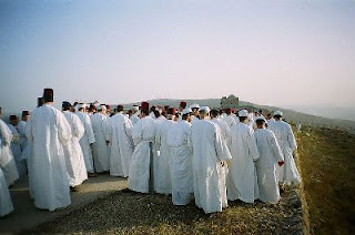
       Samaritans' religion is like a somehow outdated version of Judaism, they have different 10 commandments; do not accept the Talmud and practice animal sacrifice. Most importantly they consider Mount Gerizim near Nablus in Palestine as the place God has chosen for his temple, so it is holy for them. They were at times probably as numerous as Jews, but following a very unsuccessful uprising against the Byzantine empire (which outlawed Samaritanism and built a church on Mount Gerizim) in the years 529-531 they got scattered and most of them changed their religion and beliefs, and slowly merged with the predominantly Muslim population around the Middle ages. Today only around 750 people n the world consider themselves Samaritans by religion and ethnicity, half of them live in the village of Kiryat Luza at their sacred hill Mount Gerizim after recent military conflicts moved them away from their homes in Nablus.Both around Israel and Palestine they are considered a distinct ethnicity with its own minority rights and both countries issue them passports.
       The hill is one of the highest mountains in Palestine, raising to 881 m (2295 ft) above sea level and is covered with shrubs. The northern side (facing Nablus) is especially steep; the Samaritan village is close to the top on the southern slope.

Coordinates: 32° 11′ 58″ N, 35° 16′ 22″ E
Google Maps 
Wikipedia Article about Mount Gerizim (in English; the image is from the Hebrew Wikipedia)
Wikipedia Article about Samaritans
Wikipedia Article about the Parable

The Dig tree - a rendezvouz gone wrong

       In 1860 two explorers - Robert O'Hara Burhe and William John Wills lead a group of 19 men to explore the inlands of Australia, by the time a big mystery for the Europeans. Their goal was to start from Mellbourne and reach the gulf of Carpentaria and then go back using camels and horses. Such an expedition was a big event by the time, there was even an award for the first person to cross the continent ordered by the government of South Australia; so a crowd of 15 000 gathered to send them away.
        Burke, a former policeman was the actual leader and the most enthusiastic member of the party; Wills, the main surveyor and only 27 was more level-headed and practical.  In the beginning everything went normal,  they had food supplies for two years and the horses and camels were fine. When they approached Cooper creek (the last place visited by previous expeditions) Burke grew impatient with the slow speed, the difficult terrain and their plan which included long rests.Then a rumour reached them, that Charles Stuart, another famous explorer, has taken the challenge to cross the continent first. So instead of waiting in their base camp at Cooper creek  for the end of the hot summer and for additional supplies to arrive as was the plan, Burke decided to start for the Gulf right in the middle of summer. He took the healthiest camels and horses and left together with Wills and 2 other people and left William Brahe in command at the base camp, instructing him to wait 3 months for them. However, Wills who had a more realistic view of what lied ahead secretly instructed Brahe to wait at least four months for their return.
       So the expedition went north through the hot stony desert. Finally in February they reached the gulf (or at least the swamps at its southern end) and started back. However dysentery and the rugged terrain slowed them down and they were not able to reach the base camp in the 4 months period.
       At the base camp William Brahe waited for 4 months and a week and then left with the others, after their supplies got scarcer (because the additional ones still had not arrived) and after one of his men injured his leg. However, conscious that his colleagues may come after all he put some supplies in a crate and buried it down at the place of the camp, carving "DIG" and some small instruction where (accounts differ of what exactly was written under the big DIG sign) on the trunk of an eucalyptus tree. Exactly 9 hours after Brahe left, Burke and Wills reached the base camp and found it deserted and from the note in the supplies they found out that Brahe had left on the morning of the very same day. However the camels were so tired that they did not have a chance of reaching the others, so Burke decided on following a different route to Melbourne and the three remaining men left the camp again. Meanwhile on his way back Brahe met with the finally arriving supplying party and together with its leader William Wright returned back to the base camp to see if Burke and Wills have returned, and again found it deserted. Since the signs on the threes were unaltered they assumed that the others had not arrived and then went home.
        Burke and Wills slowly made their way south, however the heat and starvation took their toll. Apparently Burke refused to depend on the "uncivilized" natives for food and rudely refused a gift from them so they stopped trying to help. After a 2 tragic months first Wills and then a day or so later Burke died from starvation and vitamins deficiency (because they actually ate a plant that depletd the body from vitamin B1). Tha last remaining member, John King somehow managed to convince the aboriginals of his good intentions and dying state and they helped him survive until two months later a rescuing party found him.
      Today the Dig tree is an important (although not easily reachable) monument , however the sign "DIG" is no longer visible. Close to it there is another three with the face of Burke carved into it (again a little overgrown).

Coordinates: 27°37'25"S, 141° 04'32"E
Google Maps
Wikipedia Article
The whole story at the state of Victoria library

Friday, 5 October 2012

Bir Tawil - the last unclaimed piece of land

       A small area in the middle of the desert on the border of Egypt and Sudan has the distinction of being the only piece of land on Earth outside of Antarctica that is unclaimed by any country. It has no permanent population and its area is 2060 sq km (795 sq mi) in a trapezoid shape in the easternmost parts of the Sahara close to the Red sea.
       So how come this place is unclaimed? What is wrong with it, why does no one want it? Well in truth the only reason no one claims is because both parties who border it are after a bigger piece of territory and are giving this one to each other in exchange.
       In 1899 Britain and Egypt decided in their agreement about the future of Sudan that the border between Egypt and Sudan lies on the 22nd parallel North. However in a few years it became apparent that some tribes are constantly crossing the border to reach some of their traditional grazing lands, so a new agreement was made in 1902 adapting the border. The new agreement assigned some area to the south of the 22nd parallel to Egypt as it was a grazing land of the Egyptian Ababda tribe; this area would become later known as Bir Tawil. Also, some lands to the North of the parallel were assigned to Sudan and those became known as the Hala'ib triangle. However the Hala'ib triangle is about ten times bigger than Bir Tawil, has a sea access and is generally deemed to be much more valuable and Egypt never let it go, especially since the British were not really interested in the matter. So when Sudan became independent it supported the 1902 border, claiming Hala'ib and giving Bir Tawil to Egypt. Egypt however never stopped claiming the border of 1899, claiming Halaib and leaving Bir Tawil to Sudan. So that way the paradox was born - by claiming Bir Tawil each of the two nations will relinquish its claim to Hala'ib, which both are determined not to do.
       Currently both areas are under Egyptian administration. It is not really clear whether the tribes still visit the place and what is the exact border situation, since there is no road going there.

Coordinates:21° 52′ 14″ N, 33° 44′ 14″ E
Google Maps

Wikipedia Article

Tuesday, 2 October 2012

Champawat - the hunt of the legendary tiger

       Champawat is a small town in the Uttarakhand state in Northern India close to the border with Nepal. But in the thirties the town was close to extinction because of the exploits of the notorious man-eater - the Champawat tigress.
       When did the killings start is unclear; some accounts go as far back as 1890. However in 1903 the tigress was already such a great problem for the area, having allegedly killed more than 200 people, that gurkha soldiers of the Nepalese army hunted her all over Western Nepal. They somehow managed to get the tiger cross the border into India, where she became even deadlier - 234 victims in just 4 years. Nobody felt safe. Legends circulated that she was so brave that she hunted during the day, went around the streets and even did not hesitate to break into houses if she felt there is pray inside. Local authorities offered numerous rewards and militia went into the jungle to find her, but they met no success - the fear was so strong that even when confronted by the tiger most people were afraid to shoot her and hoped that they will manage to escape.
       So it was 1907 when the famous hunter Jim Corbett heard about the tiger. He was also an avid conservationist and wanted to kill tigers only when they were proven to be man-eaters, however in this case there was no doubt. He ordered the cancelling of all awards and hunting parties (in his words because no hunter hunts for awards and no hunter wants to be shot by colleagues) and went to the area, first to the town of Pali. He found the town streets empty, after the last victim 5 days ago all people were locked in their homes and the threat of starvation was imminent. Corbett's appearance was met with apathy at first, but after he survived a night outside while waiting for the tiger to show up he gained the trust of the locals and even persuaded them to harvest their crops while he stood guard nearby. He proceeded by carefully listening to all accounts and since he thought they were mostly unreliable - to visit the scenes where the tragedies happened.and concluded that the tiger has moved to the Champawat area.
       After a day or so in Champawat another victim was struck at the other end of town. Corbett was quick - he ran after the tiger mere half an hour after the incident. He followed the blood trail for about four hours until both the tigress and he managed to escape from each other; on the way he found a piece of human leg which greatly distressed him. On the next day he arranged a party of locals to make as much noise as possible on the hill with guns and drums as he waited patiently for the tigress to run away from the noise.After a series of misunderstandings with everyone he still had to run after her through the grassy fields, but finally he managed to shoot her three times with two different guns.
       While the crowds were celebrating around him Corbett discovered that the tiger's two canine teeth were broken, making her unable to hunt her regular pray and leading to her becoming a man-eater. He kept the skin and went around the area showing it to everyone so that the villagers knew they were now free. In 1944 he wrote a book giving this and various other accounts of of dangerous man-eaters. Currently, there is a plaque in the town on the place where the famous tiger was brought down for everyone to see, around a km from where she was shot. The picture of Corbett here is however most probably of another tiger (accounts of the matters are unclear).

Coordinates: 29° 19′ 48″ N, 80° 6′ 0″ E
Google Maps
Corbett's Book, The Man-Eaters of Kumaon